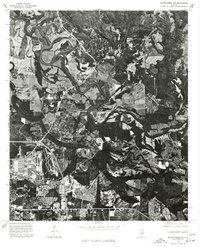
1975 Map of Mount Meigs NW
USGS Topo · Published 1977About this map
The meandering course of the Tallapoosa River dominates this mid-1970s orthophotoquad, which captures the rural-urban transition east of Montgomery. While the western edge of the image shows the encroaching development and road networks of the state capital, the remainder of the landscape is defined by the tight oxbows and dense bottomland vegetation of the river valley. The settlement of Madison appears amidst a pattern of large agricultural tracts and woodland, reflecting the area's character before the significant suburban expansion of later decades. This aerial perspective, compiled by the U.S. Geological Survey from 1975 photography, provides a rare visual record of land use and river morphology during a period of steady growth in the Alabama Black Belt.
Find a feature on this map
3 named features on this map. Tap any name to fly to it.
Don’t see what you’re looking for? This feature index may not catch every label — zoom into the map to look around manually.
Map Details
Editions of this 1975 Mount Meigs NW Map
This is the sole edition of this map. No revisions or reprints were ever made.
Other maps of this area

1901 · Wetumpka
USGS Topo · 1:125,000

1901 · Wetumpka
USGS Topo · 1:62,500

1903 · Wetumpka
USGS Topo · 1:125,000

1927 · Montgomery
USGS Topo · 1:48,000

1930 · Montgomery
USGS Topo · 1:62,500

1953 · Montgomery
USGS Topo · 1:250,000

1956 · Montgomery
USGS Topo · 1:250,000

1957 · Montgomery
USGS Topo · 1:250,000

1958 · Montgomery
USGS Topo · 1:62,500

1958 · Montgomery North
USGS Topo · 1:24,000