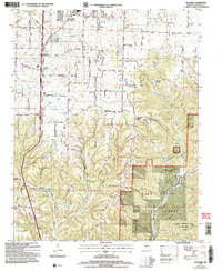
2004 Map of Selmore
USGS Topo · Published 2006About this map
The rugged boundary between upland farming and Ozark forest defines this Christian County landscape. Small communities like Selmore and Christian Center are connected by a network of rural roads named for states and local flora, such as Kentucky Road and Persimmon Road. These settlements are anchored by historic landmarks, including the Selmore Cem and several country churches like Victory Ch and Central Ch. To the north, the presence of the Alma Mine and Tuttle Mine reflects the area's geological past.
Find a feature on this map
78 named features on this map. Tap any name to fly to it.
Don’t see what you’re looking for? This feature index may not catch every label — zoom into the map to look around manually.
Map Details
Editions of this 2004 Selmore Map
This is the sole edition of this map. No revisions or reprints were ever made.
Other maps of this area

1884 · Springfield
USGS Topo · 1:125,000

1886 · Springfield
USGS Topo · 1:125,000

1907 · Forsyth
USGS Topo · 1:125,000

1937 · Ozark
USGS Topo · 1:48,000

1943 · Ozark
USGS Topo · 1:62,500

1945 · Harrison
USGS Topo · 1:250,000

1945 · Ozark
USGS Topo · 1:62,500

1949 · Harrison
USGS Topo · 1:250,000

1954 · Harrison
USGS Topo · 1:250,000

1954 · Springfield
USGS Topo · 1:250,000