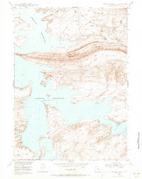
1953 Map of Seminoe Dam SE
USGS Topo · Published 1973About this map
Seminoe Reservoir dominates this 1950s landscape, its jagged shoreline reflecting a dramatic shift in the North Platte River valley as part of the Missouri River Basin project. Along the north-central shore, the prominent landform of Horse Ridge runs east-to-west, dictating the local drainage patterns of Big Draw and Sip Creek. The area retains a distinct ranching character, centered on family-named sites such as McNees Ranch and Tennant Ranch near the banks of Beaver Creek. Smaller water management features like Red Reservoir and the aptly named Dry Reservoir underscore the necessity of water storage in this high-plains environment. This survey captures a moment when the reservoir was a relatively new addition to a landscape long defined by seasonal creeks and traditional grazing lands.
Find a feature on this map
13 named features on this map. Tap any name to fly to it.
Don’t see what you’re looking for? This feature index may not catch every label — zoom into the map to look around manually.
Map Details
Editions of this 1953 Seminoe Dam SE Map
3 editions found
Other maps of this area

1893 · Fort Steele
USGS Topo · 1:125,000

1914 · Hanna
USGS Topo · 1:62,500

1914 · Walcott
USGS Topo · 1:62,500

1953 · Seminoe Dam NE
USGS Topo · 1:24,000

1953 · Seminoe Dam
USGS Topo · 1:24,000

1953 · Seminoe Dam SW
USGS Topo · 1:24,000

1953 · Seminoe Dam SE
USGS Topo · 1:24,000

1953 · Schneider Ridge
USGS Topo · 1:24,000

1953 · Beaver Creek
USGS Topo · 1:24,000

1954 · Rawlins
USGS Topo · 1:250,000