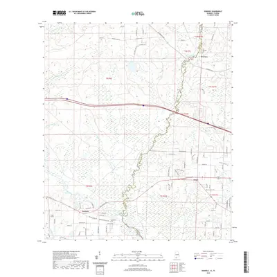
2020 Map of Seminole
USGS Topo · Published 2020About this map
The Perdido River serves as the prominent natural boundary between Baldwin Co, Alabama, and Escambia County, Florida, in this 2020 landscape. This borderland region is characterized by a dense network of waterways, including the Styx River, Rices Br, and Bear Br, which drain into the main river channel. Settlement patterns are concentrated in small communities such as Seminole, Beulah, and Muscogee, each situated amidst a grid of rural roads and residential enclaves. Local history and genealogy interests are anchored by landmarks like the Old Muscogee Cem and Mitchell Cem, while Vaughn Airport provides a distinct aviation landmark in the southwestern corner. The mapping of the Perdido River State Trail (Water) reflects the modern transition of these river corridors into recreational resources, while the presence of family-named roads like Elvis Presley Blvd and C R Watson Rd highlights the local character of the area.
Find a feature on this map
91 named features on this map. Tap any name to fly to it.
Don’t see what you’re looking for? This feature index may not catch every label — zoom into the map to look around manually.
Map Details
Editions of this 2020 Seminole Map
This is the sole edition of this map. No revisions or reprints were ever made.
Other maps of this area

1920 · Robertsdale
USGS Topo · 1:62,500

1921 · Bon Secour
USGS Topo · 1:62,500

1921 · Fort Barrancas
USGS Topo · 1:62,500

1921 · Muscogee
USGS Topo · 1:62,500

1941 · Fort Barrancas
USGS Topo · 1:62,500

1941 · Muscogee
USGS Topo · 1:62,500

1941 · Robertsdale
USGS Topo · 1:62,500

1941 · Foley
USGS Topo · 1:62,500

1943 · Robertsdale
USGS Topo · 1:62,500

1943 · Muscogee
USGS Topo · 1:62,500