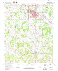
1972 Map of Seminole
USGS Topo · Published 1979About this map
Seminole serves as the industrial and educational anchor of this central Oklahoma landscape, where the Chicago Rock Island and Pacific railroad bisects a town defined by its municipal parks and local schools like Woodrow Wilson Sch and Lincoln Sch. The surrounding terrain is heavily marked by the region's petroleum history, with numerous Oil Wells and a Refinery dotting the outskirts. To the south, the settlement of Bowlegs sits above the Little River, while the rural areas are peppered with small family and community landmarks such as Cudjo Cem and Mekusukey Ch. This survey illustrates the transition from an intensive mineral-extraction economy toward a more established municipal infrastructure, including the expansion of Seminole Jr College and the Seminole Municipal Country Club. Waterways like Wewoka Creek weave through the northeastern sector, providing a natural contrast to the industrial footprint of the sprawling oil fields.
Find a feature on this map
38 named features on this map. Tap any name to fly to it.
Don’t see what you’re looking for? This feature index may not catch every label — zoom into the map to look around manually.
Map Details
Editions of this 1972 Seminole Map
3 editions found
Other maps of this area

1896 · Seminole and Prague
USGS Topo · 1:125,000

1907 · Maud
USGS Topo · 1:62,500

1908 · Maud
USGS Topo · 1:62,500

1909 · Shawnee
USGS Topo · 1:62,500

1954 · Oklahoma City
USGS Topo · 1:250,000

1957 · Oklahoma City
USGS Topo · 1:250,000

1963 · Oklahoma City
USGS Topo · 1:250,000

1967 · Prague SW
USGS Topo · 1:24,000
1967 · Earlsboro
USGS Topo · 1:24,000

1967 · Prague SE
USGS Topo · 1:24,000