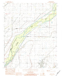
1983 Map of Senath
USGS Topo · Published 1984About this map
The St Francis River forms a shifting boundary between Missouri and Arkansas, defining a landscape dominated by complex drainage systems and flood control in the early 1980s. The town of Senath stands as a primary regional hub, served by the Burlington Northern railroad. Outside the main settlement, a series of man-made waterways like the Big Slough Ditch, Varney River Ditch, and Honey Cypress Ditch crisscross the lowlands of Salem and Independence townships. This network of ditches and bayous, including Grassy Bayou and Blue Cane Slough, illustrates the extensive agricultural reclamation of the Bootheel. Local industry and commerce are marked by Mitchell Mill and Johnson Mill, while the Ben Cash Memorial State Wildlife Area preserves a significant portion of the riverine environment near Bear Island. Smaller settlements like Leonard and Austin provide localized points of interest for genealogists.
Find a feature on this map
35 named features on this map. Tap any name to fly to it.
Don’t see what you’re looking for? This feature index may not catch every label — zoom into the map to look around manually.
Map Details
Editions of this 1983 Senath Map
This is the sole edition of this map. No revisions or reprints were ever made.
Other maps of this area

1934 · Kennett
USGS Topo · 1:62,500

1935 · Rector
USGS Topo · 1:62,500

1940 · Marmaduke
USGS Topo · 1:62,500

1940 · Kennett
USGS Topo · 1:62,500

1940 · Piggott
USGS Topo · 1:62,500

1956 · Kennett
USGS Topo · 1:62,500

1956 · Piggott
USGS Topo · 1:62,500

1957 · Poplar Bluff
USGS Topo · 1:250,000

1958 · Marmaduke
USGS Topo · 1:62,500

1958 · Rector
USGS Topo · 1:62,500