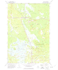
1972 Map of Seney
USGS Topo · Published 1975About this map
The Soo Line railroad bisects this Upper Peninsula landscape, connecting the settlement of Seney to the surrounding timberlands of the Grand Sable State Forest. In the early 1970s, the region is defined by a complex hydrology of natural and engineered water systems, including the Fox River and the extensive Twomile Ditch. To the south, the Seney National Wildlife Refuge dominates the terrain with its organized series of impoundments, from A Pool to M Pool, supporting local waterfowl and conservation efforts near the Refuge Headquarters. Cultural landmarks like Boot Hill Cem and the Wigwam Picnic Area reflect the local history and recreational use of the Manistique River valley. This survey documents the transition from early industrial extraction, evidenced by an Old Railroad Grade, to a landscape managed for state and federal conservation.
Find a feature on this map
50 named features on this map. Tap any name to fly to it.
Don’t see what you’re looking for? This feature index may not catch every label — zoom into the map to look around manually.
Map Details
Editions of this 1972 Seney Map
2 editions found
Other maps of this area

1931 · Seney SW
USGS Topo · 1:31,680

1931 · Seney NW
USGS Topo · 1:31,680

1931 · Manistique River NE
USGS Topo · 1:31,680

1931 · Driggs Lake NE
USGS Topo · 1:31,680

1931 · Seney SE
USGS Topo · 1:31,680

1931 · Blaney NE
USGS Topo · 1:31,680

1931 · Blaney NW
USGS Topo · 1:31,680

1931 · Driggs Lake SE
USGS Topo · 1:31,680

1954 · Sault Sainte Marie
USGS Topo · 1:250,000

1956 · Sault Sainte Marie
USGS Topo · 1:250,000