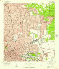
1955 Map of Settegast
USGS Topo · Published 1957About this map
The Settegast Yards and Englewood Yards dominate the industrial landscape of northeast Houston in the mid-1950s, highlighting the city's role as a massive rail hub. Large-scale infrastructure projects, including Channel Dredgings leading to the Turning Basin, define the southern portion of the map, where Buffalo Bayou and White Oak Bayou converge. This survey documents the rapid post-war expansion into suburban enclaves like Westfield Estates, Melrose Park, and Greenwood Village, while maintaining a high density of local landmarks including Kashmere Gardens Sch and Smiley High Sch. The map records numerous family-oriented landmarks and neighborhood institutions, from Farrington Chapel and Hibbard Memorial Ch to the Oak Park Cemetery. This level of detail offers a precise view of the residential and industrial growth that reshaped Houston before the full development of the modern freeway system.
Find a feature on this map
154 named features on this map. Tap any name to fly to it.
Don’t see what you’re looking for? This feature index may not catch every label — zoom into the map to look around manually.
Map Details
Editions of this 1955 Settegast Map
This is the sole edition of this map. No revisions or reprints were ever made.
Other maps of this area

1915 · Bellaire
USGS Topo · 1:24,000

1915 · Park Place
USGS Topo · 1:24,000

1915 · Houston Heights
USGS Topo · 1:24,000

1915 · Deepwater
USGS Topo · 1:24,000

1916 · Aldine
USGS Topo · 1:24,000

1916 · Settegast
USGS Topo · 1:24,000

1916 · Fauna
USGS Topo · 1:24,000

1916 · Harmaston
USGS Topo · 1:24,000

1916 · Humble
USGS Topo · 1:24,000

1919 · Aldine
USGS Topo · 1:31,680