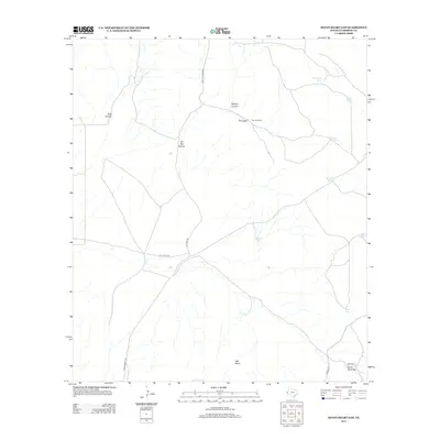
2013 Map of Seven Heart Gap
USGS Topo · Published 2013About this map
Stanton Ranch sits at the heart of this high West Texas landscape, where the naming of water sources tells a story of the challenging environment. The reliance on livestock tanks and small catchments is evident through labels like Hard Luck Tank, Bronco Mule Pond, New Deal Tank, and Baseball Tank. These features, essential for ranching survival in Culberson County, are connected by a network of rural routes including Casa De Piedras Rd, Jay Capp Rd, and Apache Rd. The terrain is defined by dramatic natural landmarks such as Old Baldy and the eponymous Seven Heart Gap. Further north, the landscape is carved by deep drainages including Wildcat Canyon, Scott Canyon, and Ed Ray Canyon, showing the complex topography that surrounds Trew Gap. A specific infrastructure point, 7 Heart Ps, likely indicates the pumping or power resources necessary for isolated operations in this remote territory.
Find a feature on this map
20 named features on this map. Tap any name to fly to it.
Don’t see what you’re looking for? This feature index may not catch every label — zoom into the map to look around manually.
Map Details
Editions of this 2013 Seven Heart Gap Map
This is the sole edition of this map. No revisions or reprints were ever made.
Other maps of this area

1906 · Van Horn
USGS Topo · 1:125,000

1928 · Kent
USGS Topo · 1:125,000

1954 · Van Horn
USGS Topo · 1:250,000

1958 · Van Horn
USGS Topo · 1:250,000
1964 · Goat Canyon
USGS Topo · 1:24,000

1964 · Watson Ranch
USGS Topo · 1:24,000
1970 · East Hunter Canyon
USGS Topo · 1:24,000

1972 · Seven Heart Gap
USGS Topo · 1:24,000

1972 · Square Mesa
USGS Topo · 1:24,000
1973 · Dome Hill
USGS Topo · 1:24,000