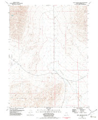
1982 Map of Seven Troughs NW
USGS Topo · Published 1982About this map
Bluewing Mountains and the rising slopes of the Seven Troughs Range dominate this 1982 Pershing County landscape. The topography captures the stark transition between high-desert ridges and the expansive basin floors of Kumiva Valley and Granite Springs Valley. Compiled from 1970s aerial photography, the map documents an arid environment where water is a critical but rare landmark, specifically noting a isolated Spring at the base of the mountains. The survey reflects the isolated character of this region, defined by unimproved roads and bench marks that serve as the primary markers of human surveying across the Great Basin terrain.
Find a feature on this map
6 named features on this map. Tap any name to fly to it.
Don’t see what you’re looking for? This feature index may not catch every label — zoom into the map to look around manually.
Map Details
Editions of this 1982 Seven Troughs NW Map
This is the sole edition of this map. No revisions or reprints were ever made.
Other maps of this area

1886 · Granite Range
USGS Topo · 1:250,000

1894 · Granite Range
USGS Topo · 1:250,000

1931 · Lovelock
USGS Topo · 1:250,000

1935 · Lovelock
USGS Topo · 1:250,000

1955 · Lovelock
USGS Topo · 1:250,000

1959 · Lovelock
USGS Topo · 1:250,000

1980 · Eagle Rock Spring
USGS Topo · 1:24,000

1981 · Twin Buttes Well
USGS Topo · 1:24,000

1981 · Gerlach
USGS Topo · 1:100,000

1981 · Bluewing Flat North
USGS Topo · 1:24,000