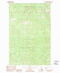
1989 Map of Seventeenmile Mountain
USGS Topo · Published 1989About this map
Colville National Forest and the Colville Indian Reservation divide this high-elevation landscape in Ferry County, where the transition between federal forest land and tribal territory is marked by a prominent mountain range. The terrain is defined by the peaks of Seventeenmile Mountain and South Seventeenmile Mountain, with the distinctive Grizzly Mtn rising to the east. A complex drainage system feeds the region, including Seventeenmile Creek and the southern flow of Twentyone Mile Creek. The eastern portion of the map is dominated by the upper reaches of Hall Creek, specifically where the North Fork Hall Creek and West Fork Hall Creek converge. This 1989 provisional survey captures the area just as modern aerial photography was being integrated into traditional topographic drafting, showing a wilderness primarily shaped by natural watersheds rather than dense human settlement.
Find a feature on this map
14 named features on this map. Tap any name to fly to it.
Don’t see what you’re looking for? This feature index may not catch every label — zoom into the map to look around manually.
Map Details
Editions of this 1989 Seventeenmile Mountain Map
2 editions found
Other maps of this area

1904 · Republic
USGS Topo · 1:125,000

1936 · Marcus
USGS Topo · 1:96,000

1942 · Marcus
USGS Topo · 1:125,000

1948 · Republic
USGS Topo · 1:62,500

1948 · Sherman Peak
USGS Topo · 1:62,500

1951 · Sherman Peak
USGS Topo · 1:62,500

1951 · Republic
USGS Topo · 1:62,500

1952 · Twin Lakes
USGS Topo · 1:62,500

1953 · Seventeenmile Mtn.
USGS Topo · 1:62,500

1954 · Okanogan
USGS Topo · 1:250,000