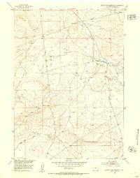
1952 Map of Seventy-one Reservoir
USGS Topo · Published 1953About this map
The high desert landscape of central Wyoming is defined here by its ranching history and the strategic management of water in the Missouri River Basin. Linn Ranch serves as a primary hub of human activity, connected to the wider region by the winding Linn Ranch Road and Love Ranch Road. The terrain is marked by the Moneta Divide and the Chalk Hills, providing a clear look at the topographic boundaries that dictated settlement and movement in this part of Fremont County. The eponymous Seventy-one Reservoir and various Windmills scattered across the quadrangle illustrate the critical infrastructure required for livestock survival on the arid plains. To the northeast, the isolated Merriam Meadows offers a change in terrain near the upper reaches of Deer Creek, showing the subtle shifts in vegetation and water availability that ranching families relied upon.
Find a feature on this map
11 named features on this map. Tap any name to fly to it.
Don’t see what you’re looking for? This feature index may not catch every label — zoom into the map to look around manually.
Map Details
Editions of this 1952 Seventy-one Reservoir Map
2 editions found
Other maps of this area

1952 · Seventy-one Reservoir
USGS Topo · 1:24,000

1952 · Squaw Butte NE
USGS Topo · 1:24,000

1952 · Squaw Butte
USGS Topo · 1:24,000

1952 · Moneta
USGS Topo · 1:24,000

1952 · Love Ranch
USGS Topo · 1:24,000

1952 · Madden
USGS Topo · 1:24,000

1952 · Butte Well
USGS Topo · 1:24,000

1952 · Moneta SE
USGS Topo · 1:24,000

1952 · Miles Ranch
USGS Topo · 1:24,000

1955 · Arminto
USGS Topo · 1:250,000