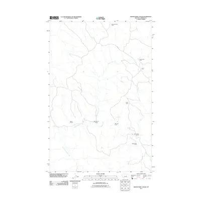
2011 Map of Seventynine Coulee
USGS Topo · Published 2011About this map
Stage Rd cuts through this corner of Garfield County, marking a modern route across a landscape defined by ranching and high-plains drainage systems. The Seven W Ranch stands as a primary point of human settlement in this cattle country, where the land is carved by deep coulees and intermittent water sources. Topographical features like Finley Butte rise above a complex network of seasonal waterways, including the winding Seventynine Coulee and Barker Coulee, which feed into the broader Lodgepole Creek basin. Local water management is evident through early 21st-century infrastructure such as Matovich Number 1 Dam and Field Number 1 Dam. These features, alongside isolated natural points like Herron Springs and Finley Spring, illustrate the vital importance of water access in this semi-arid Montana terrain.
Find a feature on this map
15 named features on this map. Tap any name to fly to it.
Don’t see what you’re looking for? This feature index may not catch every label — zoom into the map to look around manually.
Map Details
Editions of this 2011 Seventynine Coulee Map
This is the sole edition of this map. No revisions or reprints were ever made.
Other maps of this area

1954 · Jordan
USGS Topo · 1:250,000

1956 · Jordan
USGS Topo · 1:250,000

1958 · Jordan
USGS Topo · 1:250,000

1964 · Jordan
USGS Topo · 1:250,000

1965 · Germaine Coulee East
USGS Topo · 1:24,000

1965 · Germaine Coulee West
USGS Topo · 1:24,000

1965 · Cap Rock Butte
USGS Topo · 1:24,000

1967 · Nelson Coulee
USGS Topo · 1:24,000
1967 · Searl Coulee
USGS Topo · 1:24,000
1967 · Lelig Coulee
USGS Topo · 1:24,000