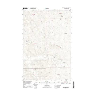
2014 Map of Seventynine Coulee
USGS Topo · Published 2014About this map
Seventynine Coulee and its surrounding drainage systems define this segment of Garfield County, where the high plains are deeply dissected by intermittent waterways and ancient geological formations. The terrain is dominated by significant elevations such as Finley Butte and the prominent Blue Ridge, which provide a contrast to the network of coulees that drain the landscape. These geographic features, including North Kirby Coulee and South Kirby Coulee, indicate a complex watershed where water management and seasonal flow have long influenced land use in this part of Montana.
Find a feature on this map
22 named features on this map. Tap any name to fly to it.
Don’t see what you’re looking for? This feature index may not catch every label — zoom into the map to look around manually.
Map Details
Editions of this 2014 Seventynine Coulee Map
This is the sole edition of this map. No revisions or reprints were ever made.
Other maps of this area

1954 · Jordan
USGS Topo · 1:250,000

1956 · Jordan
USGS Topo · 1:250,000

1958 · Jordan
USGS Topo · 1:250,000

1964 · Jordan
USGS Topo · 1:250,000

1965 · Germaine Coulee East
USGS Topo · 1:24,000

1965 · Germaine Coulee West
USGS Topo · 1:24,000

1965 · Cap Rock Butte
USGS Topo · 1:24,000

1967 · Nelson Coulee
USGS Topo · 1:24,000
1967 · Searl Coulee
USGS Topo · 1:24,000
1967 · Lelig Coulee
USGS Topo · 1:24,000