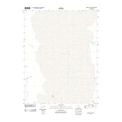
2010 Map of Sevier Lake SW
USGS Topo · Published 2010About this map
Sevier Lake dominates the central landscape of this Millard County quadrangle, showing its vast and ephemeral character as it appeared in 2010. The terrain is defined by a series of drainage patterns and seasonal water features that illustrate the arid drainage basin of western Utah. To the west, Red Wash and Steamboat Wash cut through the topography, funneling occasional runoff toward the lake bed, while Johnson Pond sits as a lonely landmark in the desert. The presence of Cricket Reservoir Number 2 and the smaller Cricket Reservoir on the eastern edge suggests localized water management efforts in this otherwise sparsely developed region. This survey serves as a precise record of the shoreline and drainage features like Cedar Wash before subsequent environmental shifts altered the desert floor.
Find a feature on this map
7 named features on this map. Tap any name to fly to it.
Don’t see what you’re looking for? This feature index may not catch every label — zoom into the map to look around manually.
Map Details
Editions of this 2010 Sevier Lake SW Map
This is the sole edition of this map. No revisions or reprints were ever made.
Other maps of this area

1953 · Richfield
USGS Topo · 1:250,000

1958 · Richfield
USGS Topo · 1:250,000

1960 · Frisco Peak
USGS Topo · 1:62,500

1960 · Beaver Lake Mts.
USGS Topo · 1:62,500

1960 · The Barn
USGS Topo · 1:62,500

1972 · Headlight Mtn
USGS Topo · 1:24,000
1972 · Needle Point
USGS Topo · 1:24,000
1972 · Sevier Lake NE
USGS Topo · 1:24,000
1972 · Sevier Lake SW
USGS Topo · 1:24,000

1980 · Wah Wah Mts. North
USGS Topo · 1:100,000