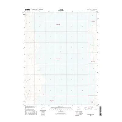
2017 Map of Sevier Lake SW
USGS Topo · Published 2017About this map
Sevier Lake dominates this arid landscape in Millard County, appearing here as a massive, seasonally shifting terminal basin. The terrain is defined by dry drainage systems that flow toward the lake bed, most notably Steamboat Wash and Red Wash in the western half of the quadrangle. These features, along with Cedar Wash at the southern edge, illustrate the intricate hydrologic patterns of the Sevier Desert. The 2017 survey also shows localized water management through the presence of Cricket Reservoir Number 2 on the eastern margin. This map documents a remote stretch of the Great Basin where the Public Land Survey System grid of Townships and Ranges provides the primary human organization over an environment otherwise shaped by intermittent water and expansive salt flats.
Find a feature on this map
11 named features on this map. Tap any name to fly to it.
Don’t see what you’re looking for? This feature index may not catch every label — zoom into the map to look around manually.
Map Details
Editions of this 2017 Sevier Lake SW Map
This is the sole edition of this map. No revisions or reprints were ever made.
Other maps of this area

1953 · Richfield
USGS Topo · 1:250,000

1958 · Richfield
USGS Topo · 1:250,000

1960 · Frisco Peak
USGS Topo · 1:62,500

1960 · Beaver Lake Mts.
USGS Topo · 1:62,500

1960 · The Barn
USGS Topo · 1:62,500

1972 · Headlight Mtn
USGS Topo · 1:24,000
1972 · Needle Point
USGS Topo · 1:24,000
1972 · Sevier Lake NE
USGS Topo · 1:24,000
1972 · Sevier Lake SW
USGS Topo · 1:24,000

1980 · Wah Wah Mts. North
USGS Topo · 1:100,000