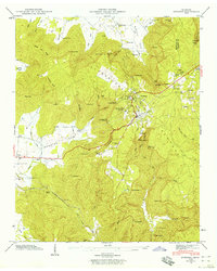
1946 Map of Sewanee
USGS Topo · Published 1959About this map
The University of the South and the Sewanee Military Academy anchor this mid-century topographic survey of the southern Cumberland Plateau. The landscape is defined by dramatic elevation changes where the plateau drops into deep recesses like Lost Cove and Hawkins Cove. This rugged geography necessitated impressive engineering feats for the era, most notably the Nashville Chattanooga and St Louis railway and the subterranean Cowan Tunnel near the western edge of the sheet.
Find a feature on this map
76 named features on this map. Tap any name to fly to it.
Don’t see what you’re looking for? This feature index may not catch every label — zoom into the map to look around manually.
Map Details
Editions of this 1946 Sewanee Map
4 editions found
Other maps of this area

1895 · Sewanee
USGS Topo · 1:125,000

1928 · Decherd
USGS Topo · 1:62,500

1936 · Sewanee
USGS Topo · 1:24,000

1936 · Alto
USGS Topo · 1:24,000

1936 · Orme
USGS Topo · 1:24,000

1936 · Sinking Cove
USGS Topo · 1:24,000

1936 · Burrow Cove
USGS Topo · 1:24,000

1936 · Monteagle
USGS Topo · 1:24,000

1936 · Winchester
USGS Topo · 1:24,000

1936 · Pitcher Ridge
USGS Topo · 1:24,000