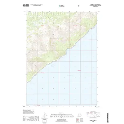
2018 Map of Seward A-1 NE
USGS Topo · Published 2018About this map
Chugach National Forest encompasses the northern mountainous reach of this coastal landscape, where high ridgelines rise sharply from the northeastern shores of the Gulf of Alaska. The terrain is defined by the steep elevation gains toward Montague Peak, overlooking the expansive waters to the south and east. This 2018 survey illustrates the interface between the dense forest management area and the open sea, providing a clear view of the coastline within the Chugach National Forest boundaries. The map reflects a largely uninhabited wilderness area, preserving the natural topography of the Chugach Mountains as they meet the northern Pacific waters.
Find a feature on this map
8 named features on this map. Tap any name to fly to it.
Don’t see what you’re looking for? This feature index may not catch every label — zoom into the map to look around manually.
Map Details
Editions of this 2018 Seward A-1 NE Map
This is the sole edition of this map. No revisions or reprints were ever made.
Other maps of this area

1948 · Cordova
USGS Topo · 1:250,000

1951 · Seward
USGS Topo · 1:250,000

1951 · Cordova
USGS Topo · 1:250,000

1951 · Seward B-1
USGS Topo · 1:63,360

1951 · Seward A-1
USGS Topo · 1:63,360

1951 · Cordova B-8
USGS Topo · 1:63,360
1951 · Cordova A-7 and A-8
USGS Topo · 1:63,360

1952 · Seward B-1
USGS Topo · 1:63,360

1953 · Seward A-1
USGS Topo · 1:63,360
1953 · Cordova B-8
USGS Topo · 1:63,360