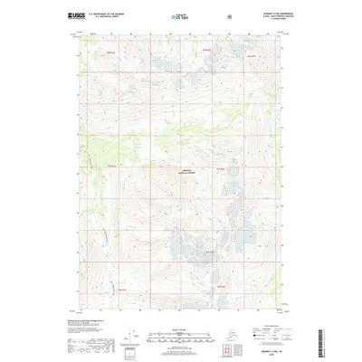
2018 Map of Seward C-6 NW
USGS Topo · Published 2018About this map
Chugach National Forest land defines this portion of the Kenai Peninsula, where the landscape is carved by numerous creek drainages. The INHT: Johnson Pass Trail winds through the western half of the map, following a path between the drainages of Bench Cr and Center Cr. This trail corridor represents a modern segment of the Iditarod National Historic Trail system, tracing a historical route through the mountains. High elevation points such as Tincan Peak and Bench Peak anchor the northeast and southeast sectors, while the Placer River flows along the eastern edge. The complex network of waterways, including Bertha Cr, Lyon Cr, and Gleason Cr, suggests the steep and varied topography of the Chugach Range in this sub-arctic environment. The lack of modern settlements highlights the area's preservation as a wilderness and recreational corridor.
Find a feature on this map
20 named features on this map. Tap any name to fly to it.
Don’t see what you’re looking for? This feature index may not catch every label — zoom into the map to look around manually.
Map Details
Editions of this 2018 Seward C-6 NW Map
This is the sole edition of this map. No revisions or reprints were ever made.
Other maps of this area

1951 · Seward
USGS Topo · 1:250,000

1951 · Seward C-6
USGS Topo · 1:63,360

1951 · Seward D-7
USGS Topo · 1:63,360

1951 · Seward C-7
USGS Topo · 1:63,360

1951 · Seward D-6
USGS Topo · 1:63,360

1952 · Seward C-6
USGS Topo · 1:63,360

1952 · Seward D-6
USGS Topo · 1:63,360

1952 · Seward D-7
USGS Topo · 1:63,360

1953 · Seward C-7
USGS Topo · 1:63,360

1953 · Seward
USGS Topo · 1:250,000