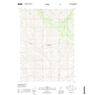
2018 Map of Seward C-7 NE
USGS Topo · Published 2018About this map
Silvertip serves as the primary landmark in this high-altitude corner of the Chugach National Forest, situated where the Seward Highway follows the valley of East Fork Sixmile Creek. The landscape is defined by a dense network of historic and modern routes, reflecting the evolution of travel through the Kenai Peninsula. Long-established paths such as the INHT - Wagon Road Trail and the INHT - Johnson Pass Trail cross the terrain alongside seasonal routes like the INHT - Turnagain Pass Snowmachi (Snow). These trails often parallel high-mountain drainages, including Granite Cr and Lynx Cr. In the southern half of the quadrangle, the terrain becomes increasingly steep and remote, marked by deep valleys carved by Juneau Cr, Mills Cr, and Timberline Cr. This 2018 survey provides an detailed look at the interface between the vital transportation corridor of the Seward Highway and the protected wilderness of the national forest.
Find a feature on this map
34 named features on this map. Tap any name to fly to it.
Don’t see what you’re looking for? This feature index may not catch every label — zoom into the map to look around manually.
Map Details
Editions of this 2018 Seward C-7 NE Map
This is the sole edition of this map. No revisions or reprints were ever made.
Other maps of this area

1951 · Seward
USGS Topo · 1:250,000

1951 · Seward C-6
USGS Topo · 1:63,360

1951 · Seward D-7
USGS Topo · 1:63,360

1951 · Seward C-7
USGS Topo · 1:63,360

1951 · Seward D-6
USGS Topo · 1:63,360

1952 · Seward C-6
USGS Topo · 1:63,360

1952 · Seward D-6
USGS Topo · 1:63,360

1952 · Seward D-7
USGS Topo · 1:63,360

1953 · Seward C-7
USGS Topo · 1:63,360

1953 · Seward
USGS Topo · 1:250,000