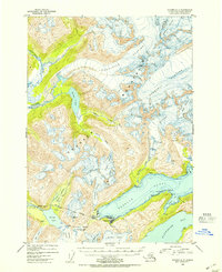
1952 Map of Seward D-5
USGS Topo · Published 1954About this map
Whittier serves as the focal point of industrial and maritime activity at the head of Passage Canal during the early 1950s. This strategic port is connected to the interior via the Alaska Railroad, which pierces the surrounding peaks through a significant tunnel near Portage Pass. The map reveals the infrastructure of the era, including a CAA Station, an Airstrip, and a cluster of tanks near the water's edge, highlighting the town's role as a vital transportation and logistics hub for the region.
Find a feature on this map
47 named features on this map. Tap any name to fly to it.
Don’t see what you’re looking for? This feature index may not catch every label — zoom into the map to look around manually.
Map Details
Editions of this 1952 Seward D-5 Map
2 editions found
Other maps of this area

1951 · Seward
USGS Topo · 1:250,000

1951 · Anchorage
USGS Topo · 1:250,000

1951 · Seward C-6
USGS Topo · 1:63,360

1951 · Seward D-5
USGS Topo · 1:63,360

1951 · Seward C-5
USGS Topo · 1:63,360

1951 · Seward D-4
USGS Topo · 1:63,360

1951 · Seward C-4
USGS Topo · 1:63,360

1951 · Seward D-6
USGS Topo · 1:63,360

1952 · Seward D-5
USGS Topo · 1:63,360

1952 · Seward C-6
USGS Topo · 1:63,360