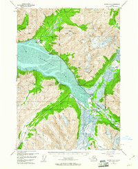
1952 Map of Seward D-6
USGS Topo · Published 1961About this map
Turnagain Arm dominates the landscape in this early 1950s survey, where the glacial waters meet the steep slopes of the Chugach National Forest. The map documents a critical transportation corridor along the northern shore, featuring the route of The Alaska Railroad and the Seward Anchorage Highway as they navigate the narrow strip between the mountains and the mudflats. Small outposts and resource-based sites like Kern and the Twentymile Sawmill (ABAND) speak to the era's industrial footprint.
Find a feature on this map
38 named features on this map. Tap any name to fly to it.
Don’t see what you’re looking for? This feature index may not catch every label — zoom into the map to look around manually.
Map Details
Editions of this 1952 Seward D-6 Map
3 editions found

Other maps of this area

1951 · Seward
USGS Topo · 1:250,000

1951 · Anchorage
USGS Topo · 1:250,000

1951 · Seward C-6
USGS Topo · 1:63,360

1951 · Seward D-5
USGS Topo · 1:63,360

1951 · Seward C-5
USGS Topo · 1:63,360

1951 · Seward D-7
USGS Topo · 1:63,360

1951 · Seward C-7
USGS Topo · 1:63,360

1951 · Seward D-6
USGS Topo · 1:63,360

1952 · Seward D-5
USGS Topo · 1:63,360

1952 · Seward C-6
USGS Topo · 1:63,360