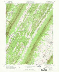
1966 Map of Shade Gap
USGS Topo · Published 1969About this map
Shade Mountain and Blacklog Mountain dominate this central Pennsylvania landscape, creating a series of parallel ridges and valleys that defined local movement in the mid-1960s. The settlement of Shade Gap serves as a crossroads, while an Old Railroad Grade traces a path through the narrow gap between the mountains, marking the path of former industrial infrastructure. Further south, the village of Neelyton sits near the Pine Grove Ch and its accompanying cemetery. The map captures the agricultural and timber-focused character of the region, specifically where Dublin and Cromwell townships meet. Local history is preserved in the numerous rural landmarks, from the Gilliland Cem in the north to the Upper Path Valley Ch near Spring Run. The terrain's linear nature is reinforced by watercourses like Blacklog Creek and Tuscarora Creek, which flow parallel to the massive ridges.
Find a feature on this map
42 named features on this map. Tap any name to fly to it.
Don’t see what you’re looking for? This feature index may not catch every label — zoom into the map to look around manually.
Map Details
Editions of this 1966 Shade Gap Map
4 editions found
Other maps of this area

1919 · Mattawana
USGS Topo · 1:62,500

1922 · Mt Union
USGS Topo · 1:48,000

1923 · Shippensburg
USGS Topo · 1:62,500

1924 · Mt. Union
USGS Topo · 1:62,500

1936 · East Waterford
USGS Topo · 1:48,000

1939 · Orbisonia
USGS Topo · 1:62,500

1940 · Orbisonia
USGS Topo · 1:62,500

1941 · East Waterford
USGS Topo · 1:62,500

1943 · Shippensburg
USGS Topo · 1:62,500

1944 · Orbisonia
USGS Topo · 1:62,500