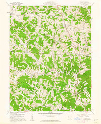
1960 Map of Shade
USGS Topo · Published 1962About this map
The Athens and Meigs county line bisects this landscape of winding ridges and deep valleys, where the Shade River and its branches define the local geography. In the early 1960s, rural life centered on small settlements like Shade, Burlingham, and Pleasanton. The map reveals a community deeply tied to its lineage and the land, evidenced by numerous family-named burial grounds including Jeffers Cem and Burson Cem. Economic activity is clearly marked by the presence of Strip Mines and scattered Oil Wells, particularly along the Gold Ridge and near Kingsbury Creek. Small-scale public institutions, such as the Burlingham Ch and Bedford Sch, appear alongside a dense network of ridge roads like Gilrey Ridge Road and Helwig Ridge Road, which follow the high ground between drainage basins.
Find a feature on this map
37 named features on this map. Tap any name to fly to it.
Don’t see what you’re looking for? This feature index may not catch every label — zoom into the map to look around manually.
Map Details
Editions of this 1960 Shade Map
3 editions found
Other maps of this area

1903 · Athens
USGS Topo · 1:62,500

1904 · Chesterhill
USGS Topo · 1:62,500

1905 · Athens
USGS Topo · 1:62,500

1906 · Chesterhill
USGS Topo · 1:62,500

1907 · Pomeroy
USGS Topo · 1:62,500

1907 · Keno
USGS Topo · 1:62,500

1947 · Columbus
USGS Topo · 1:250,000

1949 · Clarksburg
USGS Topo · 1:250,000

1956 · Clarksburg
USGS Topo · 1:250,000

1960 · Albany
USGS Topo · 1:24,000