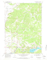
1968 Map of Shadow Mountain
USGS Topo · Published 1971About this map
Jackson Hole and the eastern reaches of Grand Teton National Park define this 1968 landscape, where the vast valley floor meets the rising slopes of Shadow Mountain. To the south, the Gros Ventre River flows toward the National Elk Refuge, passing the thermal waters of Kelly Warm Spring near the settlement of Kelly. The map records a critical geological and hydrologic environment, specifically the Gros Ventre River Geological Area and the waters of Lower Slide Lake.
Find a feature on this map
32 named features on this map. Tap any name to fly to it.
Don’t see what you’re looking for? This feature index may not catch every label — zoom into the map to look around manually.
Map Details
Editions of this 1968 Shadow Mountain Map
2 editions found
Other maps of this area

1899 · Grand Teton
USGS Topo · 1:125,000

1901 · Grand Teton
USGS Topo · 1:125,000

1902 · Mt Leidy
USGS Topo · 1:125,000

1955 · Driggs
USGS Topo · 1:250,000

1958 · Driggs
USGS Topo · 1:250,000

1962 · Driggs
USGS Topo · 1:250,000

1965 · Davis Hill
USGS Topo · 1:24,000

1965 · Mount Leidy
USGS Topo · 1:24,000
1965 · Grizzly Lake
USGS Topo · 1:24,000

1968 · Moose
USGS Topo · 1:24,000