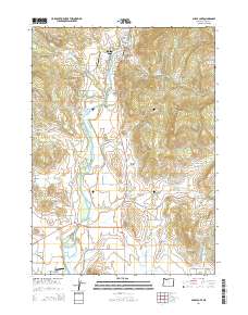
2014 Map of Shady Cove
USGS Topo · Published 2014About this map
The Rogue River carves a central path through this section of Jackson County, anchoring the town of Shady Cove as it appeared in the early 21st century. The landscape is a complex network of water management and rural aviation, featuring infrastructure like the Medford Aqueduct and the Hammel Lateral that divert water across the terrain. Numerous small-scale water bodies, including Hammel Reservoir, Todd Reservoir, and Humphrey Reservoirs, indicate a heavily managed hydraulic environment, likely supporting the local agricultural and ranching operations evidenced by the East Oregon Cattle Company Airport.
Find a feature on this map
78 named features on this map. Tap any name to fly to it.
Don’t see what you’re looking for? This feature index may not catch every label — zoom into the map to look around manually.
Map Details
Editions of this 2014 Shady Cove Map
This is the sole edition of this map. No revisions or reprints were ever made.
Other maps of this area

1891 · Ashland
USGS Topo · 1:250,000

1893 · Ashland
USGS Topo · 1:250,000

1897 · Ashland
USGS Topo · 1:250,000

1938 · Medford
USGS Topo · 1:125,000

1943 · Trail
USGS Topo · 1:62,500

1954 · Medford
USGS Topo · 1:62,500

1954 · Butte Falls
USGS Topo · 1:62,500

1954 · Lakecreek
USGS Topo · 1:62,500

1955 · Medford
USGS Topo · 1:250,000

1957 · Medford
USGS Topo · 1:250,000