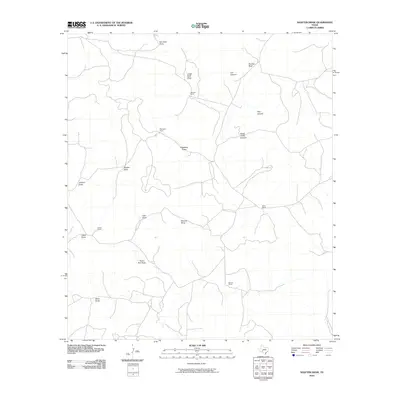
2010 Map of Shafter Draw
USGS Topo · Published 2010About this map
Isolated cattle operations and rugged drainage networks define this part of the West Texas plateau in 2010. Named ranching homesteads such as San Juan Ranch, Johnson Ranch, and Magruder Ranch serve as the primary landmarks in an arid landscape where water and topography dictate the land's use. The terrain is deeply incised by complex dry-wash systems, most notably Shafter Draw and Cocklebur Draw, which converge and snake across the territory. Notable relief features like Panther Bluff and Dutch Cove Canyon provide vertical contrast to the surrounding flats. For the genealogist or local historian, these family-named rances—including Nicks Ranch and Karnes Ranch—indicate the persistence of the ranching legacy in Crockett County into the 21st century. The map also records smaller hydrologic features such as Taylor Box Draw and Jesus Draw, illustrating the fine-grained mapping of the region's intermittent water courses.
Find a feature on this map
24 named features on this map. Tap any name to fly to it.
Don’t see what you’re looking for? This feature index may not catch every label — zoom into the map to look around manually.
Map Details
Editions of this 2010 Shafter Draw Map
This is the sole edition of this map. No revisions or reprints were ever made.
Other maps of this area

1954 · Sonora
USGS Topo · 1:250,000

1958 · Sonora
USGS Topo · 1:250,000

1967 · Flat Rock Draw SE
USGS Topo · 1:24,000

1967 · Flat Rock Draw SW
USGS Topo · 1:24,000

1967 · Ozona SE
USGS Topo · 1:24,000

1967 · Shafter Draw
USGS Topo · 1:24,000

1967 · Hudspeth Draw
USGS Topo · 1:24,000

1967 · Caverns Of Sonora
USGS Topo · 1:24,000
1967 · Hospital Ranch
USGS Topo · 1:24,000

1969 · Wild Horse Canyon
USGS Topo · 1:24,000