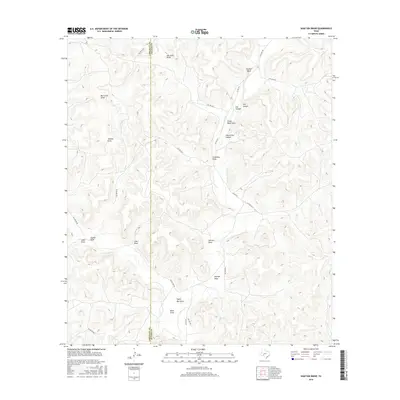
2016 Map of Shafter Draw
USGS Topo · Published 2016About this map
The boundary between Crockett County and Sutton County cuts vertically through this West Texas landscape, where the terrain is defined by a dense network of intermittent watercourses. Notable drainage features like Shafter Draw, San Juan Draw, and Bull Clod Draw carve deep pathways toward the south and west. The topography is particularly sharp around Panther Bluff and the nearby Cat Canyon and Hog Canyon, illustrating the erosional patterns of the Edwards Plateau.
Find a feature on this map
27 named features on this map. Tap any name to fly to it.
Don’t see what you’re looking for? This feature index may not catch every label — zoom into the map to look around manually.
Map Details
Editions of this 2016 Shafter Draw Map
This is the sole edition of this map. No revisions or reprints were ever made.
Other maps of this area

1954 · Sonora
USGS Topo · 1:250,000

1958 · Sonora
USGS Topo · 1:250,000

1967 · Flat Rock Draw SE
USGS Topo · 1:24,000

1967 · Flat Rock Draw SW
USGS Topo · 1:24,000

1967 · Ozona SE
USGS Topo · 1:24,000

1967 · Shafter Draw
USGS Topo · 1:24,000

1967 · Hudspeth Draw
USGS Topo · 1:24,000

1967 · Caverns Of Sonora
USGS Topo · 1:24,000
1967 · Hospital Ranch
USGS Topo · 1:24,000

1969 · Wild Horse Canyon
USGS Topo · 1:24,000