
1967 Map of Shafter Draw
USGS Topo · Published 1970About this map
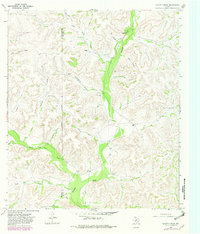
The West Texas ranchlands along the border of Sutton and Crockett counties are defined by a complex network of dry watercourses in this 1967 survey. Prominent drainage systems like Granger Draw and Shafter Draw carve through the plateau, creating a landscape where water access was the primary driver of human activity. The map records a series of established pastoral outposts including Johnson Ranch, Magruder Ranch, and Nicks Ranch, each strategically positioned relative to the draws. Isolated water sources, documented here as Shafter Well, Indian Well, and Bean Well, highlight the infrastructure required for livestock operations in this arid environment. An Indefinite Boundary runs between Cave Draw and Slocum Draw, reflecting the challenges of precise surveying in this rugged canyon-and-draw topography during the mid-20th century. Numerous small Gravel Pits are scattered near the major draws, indicating local material extraction for ranch road maintenance.
Find a feature on this map
27 named features on this map. Tap any name to fly to it.
Don’t see what you’re looking for? This feature index may not catch every label — zoom into the map to look around manually.
Map Details
Editions of this 1967 Shafter Draw Map
2 editions found
Other maps of this area

1954 · Sonora
USGS Topo · 1:250,000

1958 · Sonora
USGS Topo · 1:250,000

1967 · Flat Rock Draw SE
USGS Topo · 1:24,000

1967 · Flat Rock Draw SW
USGS Topo · 1:24,000

1967 · Ozona SE
USGS Topo · 1:24,000

1967 · Hudspeth Draw
USGS Topo · 1:24,000

1967 · Caverns Of Sonora
USGS Topo · 1:24,000
1967 · Hospital Ranch
USGS Topo · 1:24,000

1969 · Wild Horse Canyon
USGS Topo · 1:24,000

1970 · Brushy Draw
USGS Topo · 1:24,000