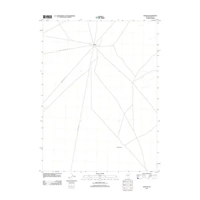
2012 Map of Shafter
USGS Topo · Published 2012About this map
Shafter serves as a critical junction for remote infrastructure in eastern Elko County during the early 21st century. The map highlights a landscape dominated by transit and utility corridors, where the Bureau Of Land Mgmt Road 1051 and several stretches of Rr Maintenance Rd intersect at this isolated rail settlement. These routes provide essential access across the Great Basin terrain, characterized by sparse vegetation and significant elevation markers like Shafter Knoll to the south. This survey documents the intersection of modern land management and historic rail corridors, showing how the movement of goods and resources continues to shape the footprint of the Nevada desert.
Find a feature on this map
4 named features on this map. Tap any name to fly to it.
Don’t see what you’re looking for? This feature index may not catch every label — zoom into the map to look around manually.
Map Details
Editions of this 2012 Shafter Map
This is the sole edition of this map. No revisions or reprints were ever made.
Other maps of this area

1953 · Spruce Mountain 4
USGS Topo · 1:62,500

1955 · Elko
USGS Topo · 1:250,000

1958 · Elko
USGS Topo · 1:250,000

1962 · Elko
USGS Topo · 1:250,000

1965 · Elko
USGS Topo · 1:250,000

1968 · Independence Valley NE
USGS Topo · 1:24,000

1968 · Independence Valley SE
USGS Topo · 1:24,000
1971 · Hardy Creek
USGS Topo · 1:24,000

1971 · West Morris Basin
USGS Topo · 1:24,000
1971 · Silver Zone Pass
USGS Topo · 1:24,000