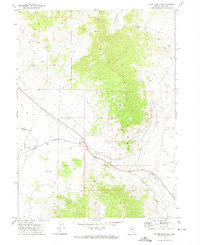
1971 Map of Silver Zone Pass
USGS Topo · Published 1974About this map
The Toano Range dominates this corner of Elko County, forming a high barrier that forced the engineering of the Western Pacific railroad and regional utility corridors. In the early 1970s, the transit through Silver Zone Pass illustrates a classic Great Basin transportation bottleneck, where rail lines, an Aqueduct, and early highways converge to navigate the steep terrain. The railroad's solution to the grade is remarkably preserved here at The Loop, a major curve designed to manage the descent into the Silver Zone Basin. Settlement is sparse, represented by small railroad-related points like Cliffside and the namesake Silver Zone. Evidence of local utility and aviation history appears through features like the Airway Beacon and Silver Zone Well, while the high country contains cattle-ranching remnants like a Corral and isolated water sources including Collar and Elbow Spring.
Find a feature on this map
22 named features on this map. Tap any name to fly to it.
Don’t see what you’re looking for? This feature index may not catch every label — zoom into the map to look around manually.
Map Details
Editions of this 1971 Silver Zone Pass Map
2 editions found
Other maps of this area

1955 · Wells
USGS Topo · 1:250,000

1955 · Elko
USGS Topo · 1:250,000

1958 · Wells
USGS Topo · 1:250,000

1958 · Elko
USGS Topo · 1:250,000

1961 · Wells
USGS Topo · 1:250,000

1962 · Elko
USGS Topo · 1:250,000

1965 · Elko
USGS Topo · 1:250,000
1967 · Pilot Peak SW
USGS Topo · 1:24,000

1967 · Cobre SE
USGS Topo · 1:24,000

1967 · Cobre
USGS Topo · 1:24,000