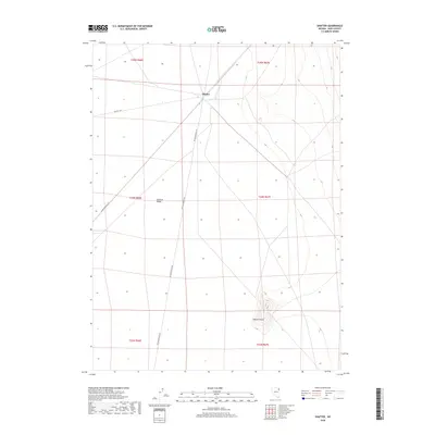
2018 Map of Shafter
USGS Topo · Published 2018About this map
Shafter stands as a primary junction in the high desert of Elko County, where historical transit corridors meet in the expansive Goshute Valley. The landscape is defined by its infrastructure, characterized by the convergence of rail lines and a network of service tracks including several stretches of RR Maintenance Rd. This area serves as a significant intersection point for rail-based logistics and regional land management, with BLM Rd 1051 providing access to the surrounding public lands. The terrain is largely level valley floor, broken only by the distinct rise of Shafter Knoll to the southeast, which provides a natural landmark overlooking the straight-line paths of the railroads and the gridded townships of the Great Basin.
Find a feature on this map
11 named features on this map. Tap any name to fly to it.
Don’t see what you’re looking for? This feature index may not catch every label — zoom into the map to look around manually.
Map Details
Editions of this 2018 Shafter Map
This is the sole edition of this map. No revisions or reprints were ever made.
Other maps of this area

1953 · Spruce Mountain 4
USGS Topo · 1:62,500

1955 · Elko
USGS Topo · 1:250,000

1958 · Elko
USGS Topo · 1:250,000

1962 · Elko
USGS Topo · 1:250,000

1965 · Elko
USGS Topo · 1:250,000

1968 · Independence Valley NE
USGS Topo · 1:24,000

1968 · Independence Valley SE
USGS Topo · 1:24,000
1971 · Hardy Creek
USGS Topo · 1:24,000

1971 · West Morris Basin
USGS Topo · 1:24,000
1971 · Silver Zone Pass
USGS Topo · 1:24,000