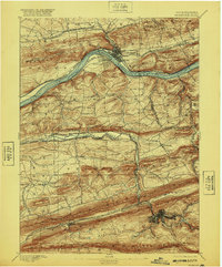
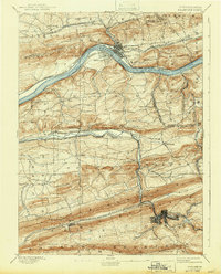
1893 Map of Shamokin
USGS Topo · Published 1920About this map
Shamokin and Danville anchor this late nineteenth-century industrial landscape, where the coal-driven economy of Northumberland and Montour counties is clearly etched into the terrain. The northern half of the sheet is dominated by the North Branch Susquehanna River, a vital corridor flanked by competing rail lines including the Pennsylvania Railroad and the Delaware Lackawanna and Western Railroad. These networks connect riverside settlements like Riverside and Mausdale to the broader regional markets.
Find a feature on this map
63 named features on this map. Tap any name to fly to it.
Don’t see what you’re looking for? This feature index may not catch every label — zoom into the map to look around manually.
Map Details
Editions of this 1893 Shamokin Map
6 editions found
Other maps of this area

1889 · Catawissa
USGS Topo · 1:62,500

1892 · Catawissa
USGS Topo · 1:62,500

1892 · Lykens
USGS Topo · 1:62,500

1892 · Shamokin
USGS Topo · 1:62,500

1892 · Pine Grove
USGS Topo · 1:62,500

1893 · Sunbury
USGS Topo · 1:62,500

1893 · Lykens
USGS Topo · 1:62,500

1893 · Shamokin
USGS Topo · 1:62,500

1893 · Millersburg
USGS Topo · 1:62,500

1894 · Catawissa
USGS Topo · 1:62,500