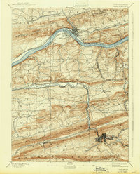
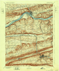
1893 Map of Shamokin
USGS Topo · Published 1943About this map
Danville and Riverside anchor this late 19th-century survey of Northumberland and Montour counties, where the Susquehanna River cuts through the ridges of central Pennsylvania. The landscape is defined by the heavy presence of coal-era infrastructure, particularly the dense concentration of rail lines such as the Philadelphia and Reading Railroad and the Northern Central Railroad Shamokin Division. These networks connect industrial hubs like Shamokin and Trevorton through steep gaps in Big Mountain and Mahanoy Mountain.
Find a feature on this map
70 named features on this map. Tap any name to fly to it.
Don’t see what you’re looking for? This feature index may not catch every label — zoom into the map to look around manually.
Map Details
Editions of this 1893 Shamokin Map
6 editions found
Other maps of this area

1889 · Catawissa
USGS Topo · 1:62,500

1892 · Catawissa
USGS Topo · 1:62,500

1892 · Lykens
USGS Topo · 1:62,500

1892 · Shamokin
USGS Topo · 1:62,500

1892 · Pine Grove
USGS Topo · 1:62,500

1893 · Sunbury
USGS Topo · 1:62,500

1893 · Lykens
USGS Topo · 1:62,500

1893 · Shamokin
USGS Topo · 1:62,500

1893 · Millersburg
USGS Topo · 1:62,500

1894 · Catawissa
USGS Topo · 1:62,500