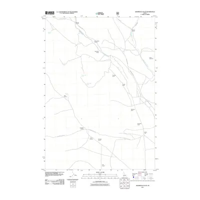
2011 Map of Shamrock Gulch
USGS Topo · Published 2011About this map
Shamrock Gulch and the surrounding high-desert canyons of eastern Idaho define this landscape in the early twenty-first century. The area is marked by a complex network of drainage systems, including Nicholia Canyon, Black Horse Canyon, and Gallagher Canyon, which carve through the terrain toward the southern edge of the quadrangle. Water sources are critical landmarks here, with several named springs such as Boulder Spring, Shamrock Spring, and the paired Upper Crystal Spring and Lower Crystal Spring providing vital points of reference in an otherwise arid environment.
Find a feature on this map
29 named features on this map. Tap any name to fly to it.
Don’t see what you’re looking for? This feature index may not catch every label — zoom into the map to look around manually.
Map Details
Editions of this 2011 Shamrock Gulch Map
This is the sole edition of this map. No revisions or reprints were ever made.
Other maps of this area

1955 · Dubois
USGS Topo · 1:250,000

1957 · Scott Peak
USGS Topo · 1:62,500

1957 · Edie Ranch
USGS Topo · 1:62,500

1958 · Dubois
USGS Topo · 1:250,000

1969 · Shamrock Gulch
USGS Topo · 1:24,000

1969 · Lidy Hot Springs SE
USGS Topo · 1:24,000

1969 · Copper Mtn
USGS Topo · 1:24,000

1969 · Lidy Hot Springs
USGS Topo · 1:24,000
1969 · Scott Butte
USGS Topo · 1:24,000
1969 · Snaky Canyon
USGS Topo · 1:24,000