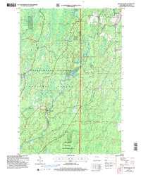
2005 Map of Shanagolden
USGS Topo · Published 2006About this map
Shanagolden sits as a lonely outpost within the sprawling timberlands of the Chequamegon-Nicolet National Forest in northern Wisconsin. The landscape is defined by its complex hydrology, dominated by the Chippewa River and its East Fork Chippewa River, which wind through low-lying marshlands and glacial kettle lakes. To the south, the Spring Brook Semi-Primitive Non-Motorized Area highlights a commitment to preserving the backcountry character of the Northwoods, while recreational access points like the Stock Farm Bridge Recreation Site provide entry to the river systems. Named landmarks such as Muskellunge Lake, Pelican Lake, and Kenyon Springs dot the terrain, connected by a network of forest routes including Mertig Road and Eder Road. This edition captures a region where managed forestry and public recreation intersect, preserving the spatial layout of industrial gravel pits and primitive boat launches.
Find a feature on this map
26 named features on this map. Tap any name to fly to it.
Don’t see what you’re looking for? This feature index may not catch every label — zoom into the map to look around manually.
Map Details
Editions of this 2005 Shanagolden Map
This is the sole edition of this map. No revisions or reprints were ever made.
Other maps of this area

1941 · Kennedy
USGS Topo · 1:48,000

1942 · Glidden
USGS Topo · 1:48,000

1942 · Clam Lake
USGS Topo · 1:48,000

1944 · Draper
USGS Topo · 1:48,000

1945 · Kennedy
USGS Topo · 1:48,000

1945 · Clam Lake
USGS Topo · 1:48,000

1945 · Glidden
USGS Topo · 1:48,000

1947 · Draper
USGS Topo · 1:48,000

1953 · Ashland
USGS Topo · 1:250,000

1953 · Rice Lake
USGS Topo · 1:250,000