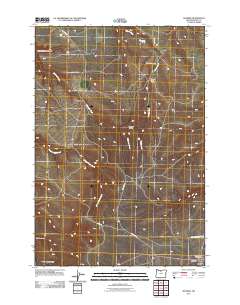
2011 Map of Shaniko
USGS Topo · Published 2011About this map
Shaniko serves as the primary landmark in this section of Wasco County, situated in the high desert landscape of North-Central Oregon. The town’s infrastructure, including the Shaniko Post Office, is documented alongside the sparse but vital water sources like Homestead Spring and the drainage network of Bakeoven Creek. The map provides significant genealogical value through the inclusion of the Bakeoven Cemetery and the Hinton-Ward Ranch, which reflect the region's enduring agricultural and ranching legacy. Local topography is defined by dramatic named features such as Nachter Butte, Little Dead Dog Canyon, and Mary McKinley Draw. Long-established transit routes are preserved here via Bakeoven Rd and Hoech Rd, which connect the isolated settlement of Bakeoven to the surrounding high plateau.
Find a feature on this map
17 named features on this map. Tap any name to fly to it.
Don’t see what you’re looking for? This feature index may not catch every label — zoom into the map to look around manually.
Map Details
Editions of this 2011 Shaniko Map
This is the sole edition of this map. No revisions or reprints were ever made.
Other maps of this area

1953 · The Dalles
USGS Topo · 1:250,000

1955 · Bend
USGS Topo · 1:250,000

1956 · The Dalles
USGS Topo · 1:250,000

1957 · Bend
USGS Topo · 1:250,000

1957 · The Dalles
USGS Topo · 1:250,000

1958 · Bend
USGS Topo · 1:250,000

1966 · Antelope
USGS Topo · 1:62,500

1966 · Willowdale
USGS Topo · 1:62,500

1970 · Kent
USGS Topo · 1:24,000

1970 · Macken Canyon
USGS Topo · 1:24,000