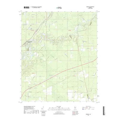
2018 Map of Sharon SE
USGS Topo · Published 2018About this map
The Pearl River meanders through this landscape, marking the complex boundary between Madison, Rankin, and Scott Counties. The river's winding path is flanked by numerous oxbow lakes and wetlands, including Tupelo Gum Lake, Richards Old River, and Alligator Lake. In the northwest, the Natchez Trace Parkway and the Natchez Trace National Scenic Trail cut across the terrain, following the historic path of the old wilderness road. This 2018 survey reveals a rural landscape where local history is anchored by family and community landmarks like Eureka Cem, Midway Cem, and the Old Iron Cem. To the southwest, the upper reaches of the Ross R Barnett Reservoir begin to take shape, while small-scale infrastructure like Pace Airstrip and a network of timber and access roads like Dummy Line Rd suggest the area's ongoing connection to forestry and aviation.
Find a feature on this map
77 named features on this map. Tap any name to fly to it.
Don’t see what you’re looking for? This feature index may not catch every label — zoom into the map to look around manually.
Map Details
Editions of this 2018 Sharon SE Map
This is the sole edition of this map. No revisions or reprints were ever made.
Other maps of this area

1922 · Morton
USGS Topo · 1:48,000

1922 · Pelahatchee
USGS Topo · 1:48,000

1924 · Pelahatchee
USGS Topo · 1:62,500

1924 · Morton
USGS Topo · 1:62,500

1950 · Pelahatchie
USGS Topo · 1:62,500

1951 · Morton
USGS Topo · 1:62,500

1952 · Pelahatchie
USGS Topo · 1:62,500

1953 · Meridian
USGS Topo · 1:250,000

1957 · Meridian
USGS Topo · 1:250,000

1960 · Sharon
USGS Topo · 1:62,500