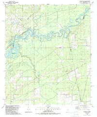
1988 Map of Sharon SE
USGS Topo · Published 1989About this map
Pearl River meanders through the heart of this landscape, its path defined by numerous oxbow lakes and cutoffs including Tupelo Gum Lake, Beach Bluff Lake, and Richards Old River. Along the western edge, the Ross R Barnett Reservoir fills the McDowell Pocket, illustrating the mid-century engineering that reshaped the basin. The presence of the Old Natzhez Trace Parkway crossing the northwestern corner connects the modern topography to one of the region’s most significant historical travel corridors. This 1980s record documents the rural character of the borderlands between Madison, Rankin, and Scott Counties, where small settlements like Ratliff and Holmes Ch are centered around country churches and cemeteries. Researchers can find several established local landmarks including Sand Hill Ch, Allen Chapel, and Lone Pine Ch, alongside industrial markers like a Landing Strip and a Pipeline that traverse the wooded terrain.
Find a feature on this map
54 named features on this map. Tap any name to fly to it.
Don’t see what you’re looking for? This feature index may not catch every label — zoom into the map to look around manually.
Map Details
Editions of this 1988 Sharon SE Map
This is the sole edition of this map. No revisions or reprints were ever made.
Other maps of this area

1922 · Morton
USGS Topo · 1:48,000

1922 · Pelahatchee
USGS Topo · 1:48,000

1924 · Pelahatchee
USGS Topo · 1:62,500

1924 · Morton
USGS Topo · 1:62,500

1950 · Pelahatchie
USGS Topo · 1:62,500

1951 · Morton
USGS Topo · 1:62,500

1952 · Pelahatchie
USGS Topo · 1:62,500

1953 · Meridian
USGS Topo · 1:250,000

1957 · Meridian
USGS Topo · 1:250,000

1960 · Sharon
USGS Topo · 1:62,500