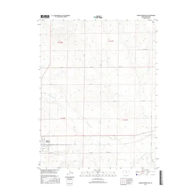
2015 Map of Sharon Springs East
USGS Topo · Published 2015About this map
Sharon Springs serves as the focal point for this Wallace County landscape, situated where the high plains meet the winding course of the Smoky Hill River. The river corridor, accompanied by tributaries like Eagletail Cr and Rose Cr, creates a distinct break in the township grid system that otherwise organizes the surrounding agricultural land. To the north, the terrain transitions toward the Red Hills and the drainage of Pond Cr. The layout of the town is clearly defined by its street grid, including Ash St, Park St, and Kennedy St, providing a detailed look at the community's footprint in the early 21st century. Rural connectivity is maintained through an extensive network of named local routes such as Tumbleweed Rd and Quartz Rd, illustrating the modern infrastructure of this western Kansas prairie region.
Find a feature on this map
21 named features on this map. Tap any name to fly to it.
Don’t see what you’re looking for? This feature index may not catch every label — zoom into the map to look around manually.
Map Details
Editions of this 2015 Sharon Springs East Map
This is the sole edition of this map. No revisions or reprints were ever made.
Other maps of this area

1954 · Goodland
USGS Topo · 1:250,000

1955 · Scott City
USGS Topo · 1:250,000

1956 · Goodland
USGS Topo · 1:250,000

1957 · Goodland
USGS Topo · 1:250,000

1958 · Scott City
USGS Topo · 1:250,000

1959 · Weskan
USGS Topo · 1:62,500

1959 · Wallace
USGS Topo · 1:62,500

1959 · Harris Draw
USGS Topo · 1:62,500

1959 · Horsethief Draw
USGS Topo · 1:62,500
1979 · Wallace
USGS Topo · 1:24,000