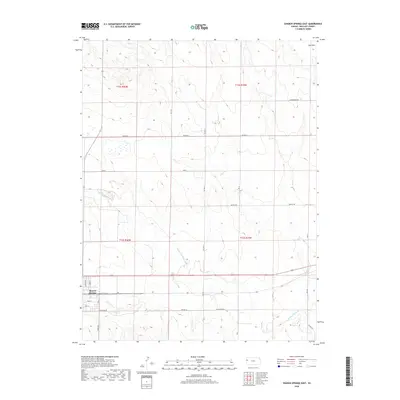
2018 Map of Sharon Springs East
USGS Topo · Published 2018About this map
Sharon Springs marks the western edge of this High Plains landscape, where the street grid including Kennedy St and S Front St meets the open terrain of Wallace County. The Smoky Hill River meanders across the central and southern portions of the sheet, joined by seasonal tributaries such as Eagletail Cr and Rose Cr. To the north, the elevation rises toward the Red Hills, an area defined by the drainage of Pond Cr and a network of section-line roads like Quartz Rd and Tumbleweed Rd. This 2018 survey reveals the modern rural infrastructure of the Kansas prairie, illustrating how the township boundaries of t12s r40w and t13s r39w organize a landscape primarily shaped by the hydrology of the Smoky Hill valley and the vast, open spaces between established ranch and farm corridors.
Find a feature on this map
21 named features on this map. Tap any name to fly to it.
Don’t see what you’re looking for? This feature index may not catch every label — zoom into the map to look around manually.
Map Details
Editions of this 2018 Sharon Springs East Map
This is the sole edition of this map. No revisions or reprints were ever made.
Other maps of this area

1954 · Goodland
USGS Topo · 1:250,000

1955 · Scott City
USGS Topo · 1:250,000

1956 · Goodland
USGS Topo · 1:250,000

1957 · Goodland
USGS Topo · 1:250,000

1958 · Scott City
USGS Topo · 1:250,000

1959 · Weskan
USGS Topo · 1:62,500

1959 · Wallace
USGS Topo · 1:62,500

1959 · Harris Draw
USGS Topo · 1:62,500

1959 · Horsethief Draw
USGS Topo · 1:62,500
1979 · Wallace
USGS Topo · 1:24,000