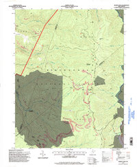
1995 Map of Sharp Knob
USGS Topo · Published 1998About this map
Monongahela National Forest dominates this highland landscape at the intersection of Webster, Randolph, and Pocahontas counties. The terrain is defined by the high ridges of Fork Lick Mountain and Mingo Mountain, where numerous strip mines are etched into the slopes above Bergoo Creek and the Elk River. The map captures a transition in water drainage, where the Gauley Mountains separate the headwaters of the Gauley River forks from the northeastward-flowing Leatherwood Creek system.
Find a feature on this map
38 named features on this map. Tap any name to fly to it.
Don’t see what you’re looking for? This feature index may not catch every label — zoom into the map to look around manually.
Map Details
Editions of this 1995 Sharp Knob Map
This is the sole edition of this map. No revisions or reprints were ever made.
Other maps of this area

1891 · Huntersville
USGS Topo · 1:125,000

1893 · Buckhannon
USGS Topo · 1:125,000

1894 · Huntersville
USGS Topo · 1:125,000

1896 · Buckhannon
USGS Topo · 1:125,000

1897 · Buckhannon
USGS Topo · 1:125,000

1913 · Hacker Valley
USGS Topo · 1:48,000

1913 · Pickens
USGS Topo · 1:48,000

1915 · Webster Springs
USGS Topo · 1:48,000

1915 · Hacker Valley
USGS Topo · 1:62,500

1915 · Pickens
USGS Topo · 1:62,500