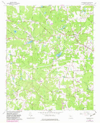
1965 Map of Sharpsburg
USGS Topo · Published 1983About this map
Sharpsburg and Turin stand as central hubs in this Georgia landscape, connected by the corridor of the Georgia Central RR during the mid-1960s. The region is defined by a dense network of country roads and family-named landmarks that reveal a deeply rooted rural community. Agricultural land and timbered tracts are divided by several branches of White Oak Creek, while numerous private lakes and millponds, such as Elders Millpond and Sibley Millpond, suggest a legacy of water-powered industry and local recreation.
Find a feature on this map
90 named features on this map. Tap any name to fly to it.
Don’t see what you’re looking for? This feature index may not catch every label — zoom into the map to look around manually.
Map Details
Editions of this 1965 Sharpsburg Map
2 editions found
Other maps of this area

1953 · Atlanta
USGS Topo · 1:250,000

1957 · Atlanta
USGS Topo · 1:250,000

1958 · Atlanta
USGS Topo · 1:250,000

1964 · Grantville
USGS Topo · 1:24,000

1965 · Newnan South
USGS Topo · 1:24,000
1965 · Newnan North
USGS Topo · 1:24,000

1965 · Tyrone
USGS Topo · 1:24,000

1965 · Madras
USGS Topo · 1:24,000

1965 · Senoia
USGS Topo · 1:24,000

1965 · Sharpsburg
USGS Topo · 1:24,000