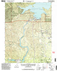
1998 Map of Shasta Dam
USGS Topo · Published 2003About this map
Shasta Dam anchors this landscape, holding back the waters of Shasta Lake at the northern edge of the Sacramento River canyon. In the late 20th century, the region shows a dense layering of industrial history and recreation, with the Whiskeytown-Shasta-Trinity National Recreation Area encompassing several earlier mining and transport sites. The terrain is marked by numerous legacy operations such as the Uncle Sam Mine, Spreadeagle Mine, and the Balaklala Mine, which are concentrated in the hills west of the river. Downstream, the City of Shasta Lake and surrounding communities like Churntown, Newtown, and Matheson reflect the residential and utility footprint of the area. Educational landmarks including Minnesota Spring Creek Sch and Toyon Sch indicate the established local settlements that persisted alongside the massive hydroelectric and water management infrastructure of the Central Valley Project.
Find a feature on this map
60 named features on this map. Tap any name to fly to it.
Don’t see what you’re looking for? This feature index may not catch every label — zoom into the map to look around manually.
Map Details
Editions of this 1998 Shasta Dam Map
This is the sole edition of this map. No revisions or reprints were ever made.
Other maps of this area

1890 · Red Bluff
USGS Topo · 1:250,000

1894 · Red Bluff
USGS Topo · 1:250,000

1901 · Redding
USGS Topo · 1:125,000

1913 · Weaverville
USGS Topo · 1:125,000

1944 · Redding
USGS Topo · 1:62,500

1944 · French Gulch
USGS Topo · 1:62,500

1946 · Lamoine
USGS Topo · 1:62,500

1946 · Redding
USGS Topo · 1:62,500

1948 · French Gulch
USGS Topo · 1:62,500

1950 · Schell Mtn
USGS Topo · 1:62,500