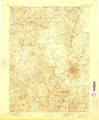
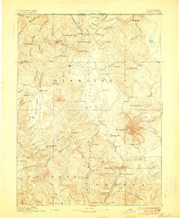
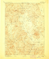
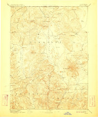
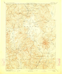
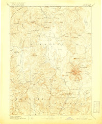
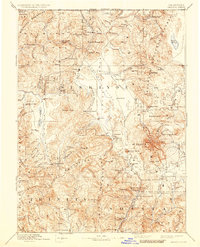
1894 Map of Shasta
USGS Topo · Published 1923About this map
Mt Shasta and its surrounding volcanic peaks dominate this late-nineteenth-century survey of Northern California. The landscape transitions from the high elevations of Shastina and Ash Creek Butte down into the wide Shasta Valley and Scott Valley. Settlement patterns reflect the era's mining and ranching economy, with activity concentrated around Yreka, French Town, and the Empire Mill. Early regional infrastructure is visible through established outposts like Fort Jones and Etna, while the southern reaches of the map show the rugged approaches to Trinity Center. The map also captures specialized mountain locations such as Horse Camp and Wagon Camp on the slopes of the Great Peak, along with several mineral springs including Lower Soda Spring and Upper Soda Spring along the upper river courses.
Find a feature on this map
103 named features on this map. Tap any name to fly to it.
Don’t see what you’re looking for? This feature index may not catch every label — zoom into the map to look around manually.
Map Details
Editions of this 1894 Shasta Map
8 editions found

Other maps of this area

1886 · Lassen Peak
USGS Topo · 1:250,000

1886 · Modoc Lava Bed
USGS Topo · 1:250,000

1886 · Shasta
USGS Topo · 1:250,000

1889 · Klamath
USGS Topo · 1:250,000

1890 · Red Bluff
USGS Topo · 1:250,000

1891 · Ashland
USGS Topo · 1:250,000

1892 · Modoc Lava-Bed
USGS Topo · 1:250,000

1892 · Lassen Peak
USGS Topo · 1:250,000

1893 · Ashland
USGS Topo · 1:250,000

1894 · Lassen Peak
USGS Topo · 1:250,000