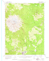
1954 Map of Shasta
USGS Topo · Published 1965About this map
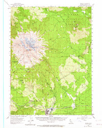
Mt Shasta dominates this mid-century survey, its massive glacial systems including Konwakiton Glacier and Wintun Glacier flowing toward the surrounding forests. The southern base of the mountain reveals a specialized landscape of early alpine recreation and industrial timber transport. While the Everitt Memorial Highway provides access to high-altitude sites like Shasta Alpine Lodge (Horse Camp) and Panther Meadow, the lowlands near McCloud are defined by the Mc Cloud River Railroad and its infrastructure. This rail network, including the Ash Creek Junction (Siding), supported the regional timber economy evidenced by local features like the Sawmill and Hooper. The map also preserves the route of Military Pass, an essential historical transit point through the southern Cascades, and documents smaller family-named landmarks such as McKenzie Butte and McGinnis Springs.
Find a feature on this map
91 named features on this map. Tap any name to fly to it.
Don’t see what you’re looking for? This feature index may not catch every label — zoom into the map to look around manually.
Map Details
Editions of this 1954 Shasta Map
8 editions found

Other maps of this area

1886 · Modoc Lava Bed
USGS Topo · 1:250,000

1886 · Shasta
USGS Topo · 1:250,000

1892 · Modoc Lava-Bed
USGS Topo · 1:250,000

1894 · Shasta
USGS Topo · 1:250,000

1932 · Bartle
USGS Topo · 1:96,000

1934 · Macdoel
USGS Topo · 1:96,000

1935 · Dunsmuir
USGS Topo · 1:125,000

1939 · Bartle
USGS Topo · 1:125,000

1941 · Macdoel
USGS Topo · 1:125,000

1948 · Weed
USGS Topo · 1:250,000