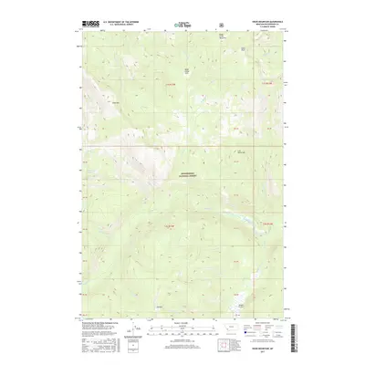
2017 Map of Shaw Mountain
USGS Topo · Published 2017About this map
Beaverhead National Forest land dominates this high-elevation terrain in Southwest Montana, where a complex network of drainages flows through the mountain ranges. The landscape is punctuated by named landmarks like Shaw Mtn and Lost Horse Mtn, with the northern reaches marked by Alder Peak and the high basins of Alder Creek Meadows. This 2017 study illustrates the remote character of the region, showing small clearings such as Bible Camp Park and Fox Park that offer rare level ground amidst the steep contours.
Find a feature on this map
44 named features on this map. Tap any name to fly to it.
Don’t see what you’re looking for? This feature index may not catch every label — zoom into the map to look around manually.
Map Details
Editions of this 2017 Shaw Mountain Map
This is the sole edition of this map. No revisions or reprints were ever made.
Other maps of this area

1955 · Dillon
USGS Topo · 1:250,000

1957 · Dillon
USGS Topo · 1:250,000

1958 · Dillon
USGS Topo · 1:250,000

1962 · Dillon
USGS Topo · 1:250,000

1962 · Pine Hill
USGS Topo · 1:24,000
1962 · Dickie Hills
USGS Topo · 1:24,000

1962 · Stewart Mountain
USGS Topo · 1:24,000
1962 · Foolhen Mountain
USGS Topo · 1:24,000

1962 · Proposal Rock
USGS Topo · 1:24,000

1965 · Dillon
USGS Topo · 1:250,000