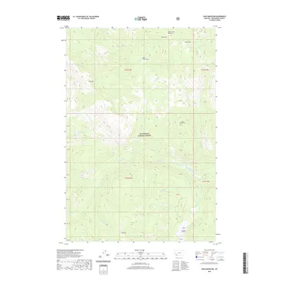
2020 Map of Shaw Mountain
USGS Topo · Published 2020About this map
Beaverhead National Forest covers much of this high-elevation landscape in southwest Montana, where intricate drainage systems like Pettengill Creek and Stone Creek carve through the mountain terrain. Notable landmarks such as Shaw Mountain and Alder Peak dominate the skyline, providing the literal backdrop for localized gathering points like Bible Camp Park and Fox Park. The presence of Stone Lakes and Alder Creek Meadows suggests a landscape of seasonal water and alpine clearing, while unique place names like Jerked Prairie reflect the vernacular history of the region. The map’s detailed record of minor tributaries, including Demijohn Creek, Whiskey Creek, and Toland Creek, offers an essential reference for understanding the hydrological patterns and land use within these forest boundaries.
Find a feature on this map
31 named features on this map. Tap any name to fly to it.
Don’t see what you’re looking for? This feature index may not catch every label — zoom into the map to look around manually.
Map Details
Editions of this 2020 Shaw Mountain Map
This is the sole edition of this map. No revisions or reprints were ever made.
Other maps of this area

1955 · Dillon
USGS Topo · 1:250,000

1957 · Dillon
USGS Topo · 1:250,000

1958 · Dillon
USGS Topo · 1:250,000

1962 · Dillon
USGS Topo · 1:250,000

1962 · Pine Hill
USGS Topo · 1:24,000
1962 · Dickie Hills
USGS Topo · 1:24,000

1962 · Stewart Mountain
USGS Topo · 1:24,000
1962 · Foolhen Mountain
USGS Topo · 1:24,000

1962 · Proposal Rock
USGS Topo · 1:24,000

1965 · Dillon
USGS Topo · 1:250,000