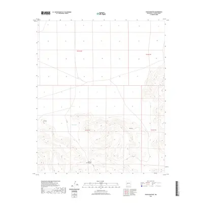
2020 Map of Shaw Mountain
USGS Topo · Published 2020About this map
Shaw Mountain and the high desert elevations of Catron County dominate this portion of the Gila region in western New Mexico. This 2020 topographical study showcases a rugged landscape defined by deep drainage systems and prominent summits, including the well-defined Eds Peak in the northwestern sector. The map provides a detailed view of the natural watercourses that have carved the terrain over centuries, most notably Shaw Canyon and the winding path of Fullerton Spring Canyon. These features demonstrate the typical drainage patterns of the high-altitude southwest, where canyons often serve as the primary conduits for seasonal runoff. Boundary lines for various townships and ranges, such as t5s r12w, overlay a largely undeveloped landscape where topographic contours reveal the complex relief of the mountain's eastern slopes and the intersecting reaches of Y Canyon.
Find a feature on this map
9 named features on this map. Tap any name to fly to it.
Don’t see what you’re looking for? This feature index may not catch every label — zoom into the map to look around manually.
Map Details
Editions of this 2020 Shaw Mountain Map
This is the sole edition of this map. No revisions or reprints were ever made.
Other maps of this area

1918 · Pelona
USGS Topo · 1:125,000

1954 · Tularosa
USGS Topo · 1:250,000

1954 · Clifton
USGS Topo · 1:250,000

1957 · Clifton
USGS Topo · 1:250,000

1958 · Clifton
USGS Topo · 1:250,000

1958 · Tularosa
USGS Topo · 1:250,000

1962 · Clifton
USGS Topo · 1:250,000

1979 · San Mateo Mountains
USGS Topo · 1:100,000

1981 · Fullerton
USGS Topo · 1:24,000
1981 · Luera Mountains NW
USGS Topo · 1:24,000