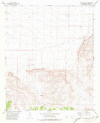
1981 Map of Shaw Mountain
USGS Topo · Published 1981About this map
Shaw Mountain and Eds Peak dominate this landscape in Catron County, New Mexico. The geography is defined by a series of high-elevation peaks and deep drainages, including the prominent Shaw Canyon. In this arid region, water sources were critical for ranching and survival, as evidenced by the dispersed network of named water points such as Ocho Juan Well, Thurgood Well, Cawley Well, and Fullerton Spring. A singular Grave marked near the center of the sheet provides a poignant point of interest for local historians, suggesting an isolated interment far from established settlements. The 1981 mapping, based on aerial photography from the mid-1970s, illustrates a sparsely populated terrain where livestock management and the pursuit of water were the primary drivers of human movement across the high desert.
Find a feature on this map
10 named features on this map. Tap any name to fly to it.
Don’t see what you’re looking for? This feature index may not catch every label — zoom into the map to look around manually.
Map Details
Editions of this 1981 Shaw Mountain Map
This is the sole edition of this map. No revisions or reprints were ever made.
Other maps of this area

1918 · Pelona
USGS Topo · 1:125,000

1954 · Tularosa
USGS Topo · 1:250,000

1954 · Clifton
USGS Topo · 1:250,000

1957 · Clifton
USGS Topo · 1:250,000

1958 · Clifton
USGS Topo · 1:250,000

1958 · Tularosa
USGS Topo · 1:250,000

1962 · Clifton
USGS Topo · 1:250,000

1979 · San Mateo Mountains
USGS Topo · 1:100,000

1981 · Fullerton
USGS Topo · 1:24,000
1981 · Luera Mountains NW
USGS Topo · 1:24,000